Skip to content

Northern Kenya, including Turkana, Marsabit, Wajir, Mandera, Garissa, Isiolo and Samburu, is dominated by arid and semi-arid conditions. Rainfall is low and erratic, evaporation is high, and rivers are mostly seasonal. For pastoral communities, refugee settlements such as Kakuma, towns, schools, health facilities and livestock, groundwater is often the only dependable source of water.
Drilling boreholes in this environment is different from drilling in the highlands. Aquifers may be deep, recharge is limited, water can be saline, access is difficult, costs are higher and mistakes have serious consequences for entire communities. This article explains the main hydrogeological features and practical lessons for boreholes in Kakuma and similar arid areas.
Geological and Hydrogeological Setting of Turkana and the North
Turkana County lies in north-western Kenya within a large sedimentary and volcanic landscape that is part of the East African Rift system, with the ancient basement exposed in places. In very broad terms:
- Sedimentary basin fill. Thick sequences of sands, gravels, silts and clays have accumulated in basins, such as those around the Kakuma area, and form aquifer systems in sand and gravel layers.
- Volcanic rocks. Lavas and volcanic deposits occur in parts of Turkana, Marsabit and surrounding areas and can host groundwater in fractured and weathered zones.
- Basement rocks. Crystalline basement outcrops in places, with groundwater limited to weathered and fractured zones.
- Alluvial deposits along seasonal rivers (laghas). Sand rivers such as the Tarach and others can store shallow groundwater beneath their beds, which communities access through scoop holes and shallow wells.
Regional studies and exploration programmes in the Turkana region have identified large groundwater systems in sedimentary basins, such as the Lotikipi basin in north-western Turkana, which have attracted interest for water supply. Details of storage, recharge and water quality in these systems remain the subject of ongoing research, so claims about their size and sustainability should be treated carefully and checked against current scientific publications and the Water Resources Authority.
Key Challenges of Drilling in Arid Northern Kenya
1. Low recharge. Because rainfall is low and evaporation high, little water infiltrates to recharge aquifers. Some aquifers contain “fossil” water recharged during wetter climatic periods thousands of years ago. Abstracting this water can amount to mining a non-renewable resource, so sustainability planning is essential.
2. Salinity and water quality. Many arid-zone groundwaters are brackish or saline, with high total dissolved solids, sodium and chloride, and sometimes high fluoride or sulphate. Evaporation, long residence times and dissolution of salts all contribute. Some boreholes yield water too saline for people but acceptable for livestock, and others are fresh enough for domestic use. Water quality testing is therefore as important as yield testing. Our articles on water quality testing and fluoride provide guidance.
3. Depth. Depths to productive aquifers vary from shallow alluvial water to several hundred metres in deep sedimentary or volcanic aquifers. Deeper boreholes cost more to drill, case and pump.
4. Variable and unpredictable yield. In fractured basement and volcanic terrain, success depends on intersecting fractures. In sedimentary basins, clay-rich layers can limit yield and cause caving or borehole instability.
5. Remote locations and logistics. Mobilising rigs, fuel, casing, water for drilling and skilled crews over long distances increases cost and time. Roads can become impassable in rains, and security considerations may apply in some areas.
6. Extreme temperatures and power. High ambient temperature affects equipment and pump operation. Grid electricity may be unavailable, which makes solar-powered pumping systems attractive, though they require proper sizing, storage and protection against theft and vandalism.
7. Competing demands and conflict. Water points in pastoral areas are focal points for people and livestock. Poorly planned boreholes can concentrate grazing pressure, cause degradation and in some contexts contribute to conflict. Community engagement and clear management arrangements are crucial.
8. Sustainability and management. Many boreholes in remote areas fail because of lack of maintenance, spare parts and management structures rather than because the aquifer is exhausted. Planning for operation and maintenance is as important as drilling.
Special Considerations for Kakuma
Kakuma, in Turkana West, hosts a large refugee camp and a growing host community town. Water demand is high, and the area has experienced water scarcity, high temperatures and rapid population growth. Projects in the area have included boreholes and other water infrastructure to supply refugee and host populations. Typical considerations include:
- Large and growing demand requiring reliable, well-managed supply systems rather than isolated boreholes.
- Water quality variability across the area, so each new borehole should be tested for salinity, fluoride, bacteria and other parameters before use.
- Integrated planning with humanitarian agencies, county government and the Water Resources Authority to avoid over-abstraction and interference between boreholes.
- Complementary sources and storage, such as sand dams, water pans and rainwater harvesting where appropriate. In sandy seasonal riverbeds, sand dams and subsurface dams can store water in the sand and improve local water security. Geotechnical design of such structures requires attention to foundation conditions and flood hydraulics.
- Monitoring of water levels and abstraction in the wider aquifer system to detect decline early.
If you are planning a project in Kakuma, engage experienced hydrogeologists and drilling contractors familiar with local conditions.
A Recommended Approach for Arid-Zone Borehole Projects
Step 1: Desktop study and regional hydrogeological review. Gather geological maps, satellite imagery, existing borehole records, groundwater level data, previous studies and reports from WRA and partners. Identify promising aquifer systems and known problem areas (saline or fluoride-rich zones).
Step 2: Remote sensing and GIS analysis. Use satellite data to map geology, lineaments, drainage and vegetation patterns, and to identify seasonal river channels and potential recharge zones. GIS-based groundwater potential mapping can guide where to concentrate fieldwork.
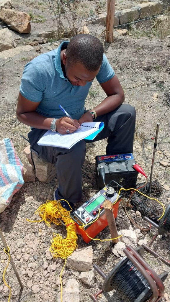
Step 3: Field reconnaissance and geophysics. Carry out geological field checks and geophysical surveys such as electrical resistivity and electromagnetic profiling to locate aquifers and delineate fresh versus saline zones. In saline environments, very low resistivities complicate interpretation, so calibration with existing boreholes and water quality data is vital.
Step 4: Siting and design. Select drilling points considering expected yield, water quality, distance to users, access and risk. Design the borehole for the formation, including appropriate casing, screens, gravel pack and sanitary protection. In unconsolidated sedimentary formations, correct screen selection and development are critical to avoid sand pumping.
Step 5: Permitting and consultation. Follow the regulatory process with the Water Resources Authority, NEMA and the county government as applicable. In community settings, involve local leaders and users early.
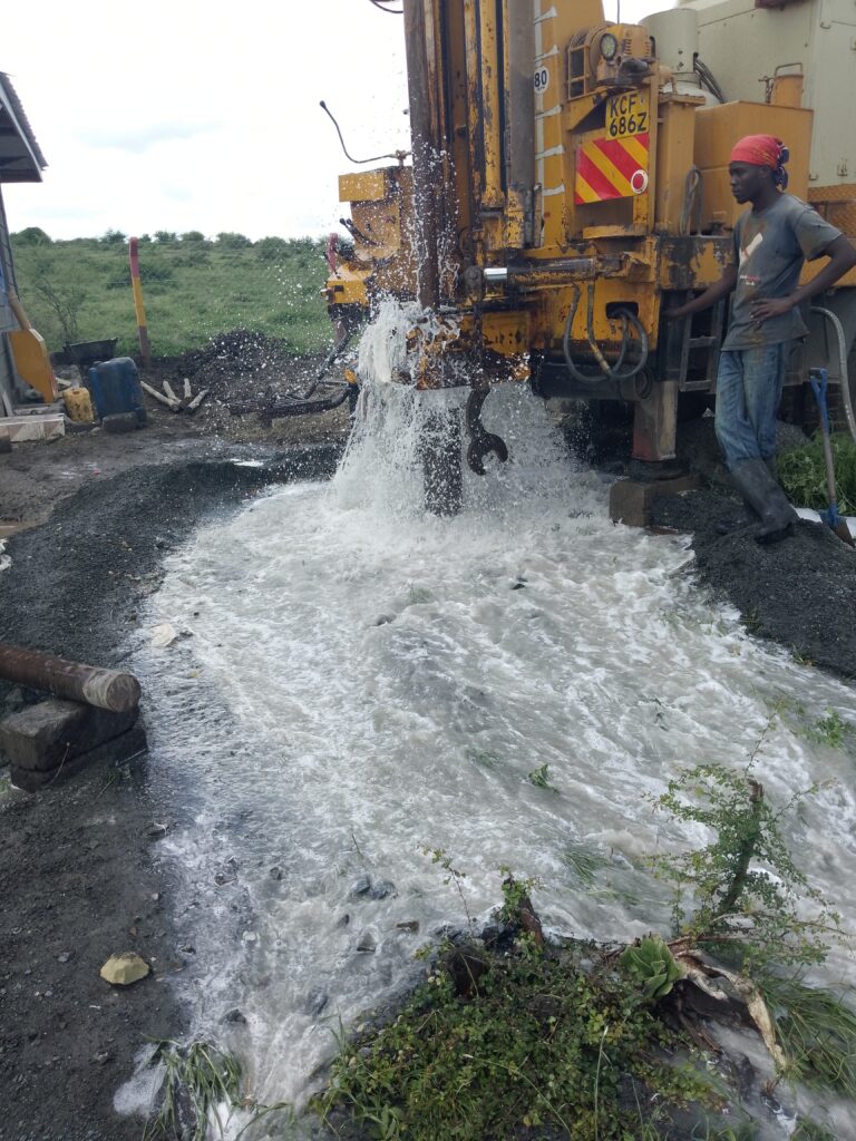
Step 6: Drilling supervision and logging. Supervise drilling, record lithology and water strikes, take water samples at different depths where feasible and adjust the design to the findings. If saline water is intersected at one depth, consider sealing it off and screening a fresher interval, if present.
Step 7: Development, test pumping and water analysis. Develop the borehole thoroughly and carry out step and constant-rate tests to determine safe yield. Conduct full water quality analysis, including bacteria, TDS, fluoride and other relevant parameters.
Step 8: Equipping and storage. Select pumps and power sources matched to the yield and head. For remote sites, solar pumping with adequate storage tanks, protective fencing and animal watering troughs placed away from the borehole can improve reliability and hygiene.
Step 9: Management, maintenance and monitoring. Set up a water management committee or operator, collect fees where appropriate to fund maintenance, train technicians, stock critical spare parts and monitor water levels and abstraction.
Cost Considerations in Remote Arid Areas
Costs in arid northern Kenya are usually higher than in central Kenya because of mobilisation distances, deeper depths, difficult drilling conditions and logistics. Major cost components include:
- Hydrogeological and geophysical survey, which may need to cover larger areas.
- Mobilisation and demobilisation of rigs and crews.
- Drilling per metre, which may be higher with hard rock, unstable formations or mud drilling.
- Casing, screens and gravel pack.
- Water for drilling, which can be a significant cost in dry areas.
- Test pumping and water analysis.
- Solar pumping system, tanks, tapstands, troughs and fencing.
- Capacity building and management arrangements.
For general context, see our borehole cost guide. Remote-area costs should be quoted specifically, and contingencies for failed or low-yield boreholes should be built into budgets.
Managing Salinity and Water Treatment
If groundwater is brackish, options include:
- Selecting a different depth or location with fresher water.
- Using brackish water for livestock or washing and fresh water for drinking, with careful management.
- Desalination by reverse osmosis, often solar-powered in remote areas. This can provide drinking water but requires capital, maintenance, spare parts and management of brine disposal.
- Blending with fresher water sources.
- Rainwater harvesting to supplement.
Each approach has costs, risks and benefits. Treatment technologies must be matched to local capacity for operation and maintenance.
Sustainability and Aquifer Protection
In low-recharge settings, over-abstraction can lead to falling water levels, deterioration of quality and failing boreholes. Good practice includes:
- Monitoring water levels, abstraction and quality at representative boreholes.
- Setting abstraction limits consistent with aquifer capacity and permit conditions.
- Spacing boreholes to reduce interference.
- Protecting recharge areas and riverbeds from degradation.
- Combining sources and avoiding dependence on a single borehole.
- Using demand management and efficient water use.
- Planning for climate variability, including droughts and floods.
Geotechnical and Environmental Considerations
Water infrastructure in arid areas, such as sand dams, water pans and tank foundations, requires geotechnical input. Flash floods in seasonal rivers can damage structures that are poorly designed. Environmental assessments help avoid harm to fragile ecosystems and ensure that new water points do not cause land degradation. Larger projects may require an Environmental Impact Assessment under Kenyan law.
Frequently Asked Questions
How deep are boreholes in Kakuma and Turkana? Depths vary widely depending on the aquifer targeted, from shallow alluvial wells to boreholes of a hundred metres or more. Site-specific hydrogeological investigation is necessary.
Is groundwater in Turkana fresh or saline? Both occur. Some areas have fresh water, while others have brackish or saline water. Test every borehole.
Can solar power run boreholes in remote areas? Yes, solar pumping is widely used because it avoids fuel costs and logistics, but it needs correct design, storage and security.
Are the large aquifers discovered in Turkana a permanent solution? Large groundwater storage does not guarantee sustainability. It depends on recharge, water quality and how the resource is managed, so careful monitoring and planning are essential.
What about sand dams? In suitable seasonal river settings, sand dams can store water in accumulated sand and complement boreholes. They require careful site selection and construction.
Who should I contact for permits? The Water Resources Authority, the county water department and NEMA, depending on project scale. Involve experienced consultants early.
Conclusion
Drilling boreholes in Kakuma and arid northern Kenya demands careful science, realistic budgeting and strong management. The region offers important groundwater resources in sedimentary basins, volcanic areas and alluvial systems, but low recharge, salinity, depth and logistics make every project more demanding. A step-by-step approach that integrates geological mapping, remote sensing, geophysics, careful water quality testing, community engagement and long-term monitoring gives the best chance of reliable, sustainable water.
For hydrogeological surveys, geological mapping, GIS and geotechnical services in northern Kenya and the wider region, contact Reg. Geol. Mbugua Githae (MGSK) via consult.innercoregeoconsultants.co.ke.