Geoscience has always been a data-heavy discipline — satellite imagery, drill logs, geophysical surveys, geochemical assays, and terrain models generate enormous volumes of information that once took teams of specialists months to interpret manually. GeoAI, the application of artificial intelligence and machine learning to geospatial and geological data, is changing that equation, allowing patterns that would take humans weeks to identify to be surfaced in a fraction of the time.
This article explains what GeoAI actually is, how it’s being applied across the geoscience industry, and what its real capabilities and limitations look like in 2026.
Defining GeoAI
GeoAI refers broadly to the use of artificial intelligence — particularly machine learning and deep learning techniques — applied to geospatial data. In a geological and geotechnical context, this typically means training algorithms to recognize patterns across satellite imagery, geophysical data, drill core, terrain models, and geochemical datasets, then using those trained models to classify, predict, or detect features automatically.
It’s important to be clear about what GeoAI is and isn’t. It’s not a replacement for geological expertise — it’s a tool that extends what geoscientists can do with the data they already collect, automating repetitive interpretive tasks and helping identify subtle patterns across datasets too large for manual review.
Core Techniques Behind GeoAI
Machine Learning Classification
Many GeoAI applications rely on supervised machine learning, where an algorithm is trained on labeled examples — say, satellite imagery pixels labeled as “altered” or “unaltered” by an experienced geologist — and then learns to classify new, unlabeled data based on patterns identified in the training set. This underpins much of the automated mapping work in remote sensing applications.
Deep Learning and Neural Networks
Deep learning, particularly convolutional neural networks (CNNs), has become especially valuable for image-based geoscience applications, since these architectures excel at recognizing spatial patterns in imagery — a natural fit for satellite data, drone imagery, and even photographs of rock core or outcrops.
Predictive Modeling
Beyond classification, machine learning models are increasingly used for predictive tasks — estimating the likelihood of mineralization at unsampled locations based on patterns learned from known deposits, or forecasting landslide susceptibility based on terrain, geology, and historical event data.
Natural Language Processing
A less visible but increasingly important application involves using natural language processing to extract structured information from unstructured historical data — old exploration reports, drill logs, and geological survey documents — making decades of legacy data searchable and usable in modern analysis, rather than sitting unused in archives.
Where GeoAI Is Being Applied
Automated Feature Mapping
Machine learning models can be trained to automatically identify and map features from satellite or aerial imagery — lithological boundaries, alteration zones, structural lineaments, or land cover changes — at a scale and speed that would be impractical for manual interpretation alone, particularly across large regional datasets.
Mineral Prospectivity Mapping
By training models on the geological, geochemical, and geophysical characteristics of known mineral deposits, GeoAI can help generate prospectivity maps that highlight areas with similar characteristics elsewhere in a region, supporting exploration targeting and helping prioritize where limited field and drilling budgets should be focused.
Automated Core Logging
Some exploration and mining operations are adopting AI-assisted core photography analysis, where trained models help identify rock type boundaries, structural features, or mineralization indicators from core photographs, speeding up the logging process and providing a consistent, repeatable first-pass interpretation for geologists to review and refine.
Landslide and Hazard Susceptibility Modeling
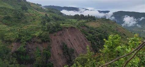
Machine learning models trained on terrain data, geology, historical landslide inventories, and triggering factors like rainfall or seismicity can generate landslide susceptibility maps across large areas, supporting hazard planning and infrastructure risk assessment at a scale that would be difficult to achieve through manual geological assessment alone.
Change Detection
AI-powered change detection algorithms can automatically flag areas of land cover or surface change between satellite image acquisitions — useful for monitoring mining rehabilitation, deforestation, illegal mining activity, or infrastructure development, without requiring a human analyst to manually compare every image pair.
Seismic and Geophysical Interpretation
In the oil, gas, and geothermal sectors, machine learning is increasingly applied to seismic data interpretation, helping identify subsurface structures, fault networks, and potential reservoir characteristics faster than traditional manual interpretation workflows.
The Value GeoAI Delivers
Speed and scale. GeoAI can process and analyze datasets — regional satellite mosaics, decades of historical reports, large drill databases — far faster than manual methods, making it possible to extract value from data that would otherwise be too time-consuming to fully utilize.
Consistency. Automated classification applies the same criteria uniformly across an entire dataset, reducing the interpreter-to-interpreter variability that can occur with purely manual mapping and interpretation.
Pattern detection beyond human perception. Machine learning models can sometimes identify subtle statistical relationships across many variables simultaneously — relationships that wouldn’t be obvious to a human reviewing the same data manually, one layer at a time.
Unlocking legacy data. Many exploration and geoscience organizations sit on decades of historical data that’s never been fully digitized or analyzed. GeoAI, particularly combined with natural language processing, offers a practical way to make this legacy information usable again.
Limitations and Realistic Expectations
GeoAI is a genuinely valuable tool, but it comes with real limitations that responsible practitioners should be upfront about.
Data quality dependency. Machine learning models are only as good as the data they’re trained on. Biased, sparse, or poor-quality training data leads to unreliable predictions, and geological training datasets — particularly for rare deposit types — are often limited.
Geological context still matters. Models can identify statistical patterns, but they don’t inherently understand geological process. A model might flag a spectral or geochemical anomaly without understanding whether it’s geologically plausible in context — which is where experienced geological review remains essential.
Risk of false confidence. Outputs from AI models can appear precise and authoritative, which sometimes leads to over-reliance on results that haven’t been adequately validated against ground truth or reviewed by an experienced geoscientist.
Not a substitute for fieldwork. GeoAI can prioritize and focus where field investigation should occur, but it doesn’t replace the need for ground verification, drilling, and direct geological observation.
The Right Way to Use GeoAI
The most effective GeoAI applications treat these tools as force multipliers for experienced geoscientists, not replacements for them. Automated methods handle the repetitive, large-scale pattern recognition tasks, freeing geologists to focus their expertise on interpretation, validation, and the judgment calls that still require human geological reasoning — particularly around geological plausibility and integration with field observations.
Organizations getting the most value from GeoAI tend to combine strong underlying data quality, appropriate model selection for the specific problem, and consistent human oversight throughout the process, rather than treating any single AI output as a final answer.
Curious how GeoAI could be applied to your exploration, hazard assessment, or geospatial project? Our team combines geological expertise with modern geospatial AI tools — get in touch to discuss what’s possible for your data.