Not every piece of land is equally safe to build on. Landslides, seismic activity, expansive soils, flooding, and subsidence can all threaten a structure’s long-term stability — and in many cases, these risks aren’t obvious from a surface inspection alone. A geological hazard assessment identifies these risks systematically, giving developers, architects, and regulators the information they need to design safely and avoid costly surprises after construction begins.
This article explains what geological hazard assessments cover, when they’re required, and how they fit into the broader development process.
What Is a Geological Hazard Assessment?
A geological hazard assessment is a study that identifies and evaluates natural hazards that could affect a proposed development site — either hazards originating at the site itself or hazards from the surrounding area that could impact it. Unlike a standard geotechnical investigation, which focuses primarily on foundation design, a hazard assessment takes a broader risk-based view, asking: what could go wrong here, how likely is it, and how severe would the consequences be?
In many jurisdictions, hazard assessments are a mandatory part of the permitting process for sites located in or near mapped hazard zones — steep slopes, floodplains, active fault zones, or areas with a documented history of ground instability.
Common Geological Hazards Assessed
Landslide and Slope Instability
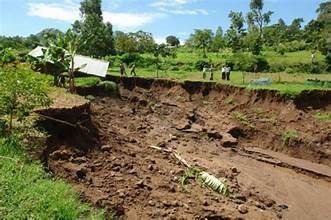
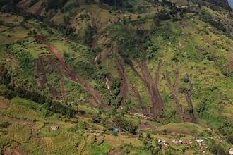
Sites on or below slopes need evaluation for both existing landslide features and susceptibility to future movement. This involves assessing slope angle, soil and rock strength, groundwater conditions, vegetation cover, and evidence of past movement such as scarps, hummocky terrain, or tilted trees. Slopes that appear stable under current conditions can become unstable following heavy rainfall, seismic shaking, or changes introduced by construction itself, such as cut-and-fill grading or altered drainage patterns.
Seismic Hazards
In earthquake-prone regions, assessments typically address several distinct but related risks: ground shaking intensity based on local soil conditions (soft soils tend to amplify shaking), surface fault rupture potential for sites near active faults, and liquefaction potential — a phenomenon where saturated, loose granular soils temporarily lose strength during strong shaking, capable of causing significant settlement or lateral spreading even where shaking damage would otherwise be limited.
Expansive and Problem Soils
Certain clay-rich soils expand significantly when wet and shrink when dry, generating enough force to crack foundations, slabs, and pavements over repeated wet-dry cycles. Identifying expansive soil conditions early allows engineers to design appropriate foundation systems — such as deepened footings or moisture barriers — rather than discovering the problem after cracking appears.
Flooding and Hydrological Hazards
While often assessed separately by hydrology specialists, geological hazard assessments frequently need to consider flood risk in conjunction with geological conditions, particularly regarding how flooding interacts with slope stability, erosion, and soil saturation.
Karst and Subsidence Risk
In areas underlain by soluble bedrock like limestone, dolomite, or gypsum, dissolution processes can create underground voids that eventually collapse, forming sinkholes. Hazard assessments in karst terrain typically involve geophysical surveys to detect subsurface voids and a careful review of regional karst mapping and sinkhole history.
Erosion
Sites with erodible soils, steep grades, or significant runoff concentration may require erosion hazard evaluation, particularly where construction activity could accelerate erosion rates or where erosion could undermine structures or infrastructure over time.
The Assessment Process
Desktop Review
As with geotechnical investigations, hazard assessments begin with a review of existing data: regional geological and hazard maps, historical aerial imagery, seismic hazard maps, previous investigations, and any documented hazard events in the vicinity. This step often determines which specific hazards warrant detailed field investigation.
Field Investigation
Depending on which hazards are relevant, fieldwork may include geological mapping, slope reconnaissance, subsurface exploration (drilling, test pits, or geophysical surveys), and groundwater assessment. For seismic hazard studies, this may also involve reviewing or commissioning site-specific seismic hazard analysis.
Hazard Characterization and Risk Evaluation
Once field data is collected, the consulting team characterizes the hazard’s extent, severity, and likelihood, often expressed in terms relevant to engineering design — for example, expected ground acceleration values for seismic design, or factor-of-safety calculations for slope stability.
Mitigation Recommendations
A hazard assessment doesn’t just identify problems — it should provide practical, actionable mitigation strategies. Depending on the hazard, this might include engineered slope stabilization, deep foundation systems, drainage improvements, setback distances from hazard zones, or in some cases, a recommendation that certain areas of a site remain undeveloped.
Why Hazard Assessments Matter Beyond Compliance
While regulatory compliance is often the immediate driver, a well-executed hazard assessment delivers value well beyond satisfying a permitting requirement.
Risk-informed design decisions. Understanding site-specific hazards allows architects and engineers to design around risk from the outset, rather than retrofitting solutions later at greater cost.
Insurance and financing considerations. Lenders and insurers increasingly require documented hazard assessments for properties in higher-risk zones, and a thorough report can support more favorable terms by demonstrating that risks have been identified and addressed.
Long-term liability protection. Developers who commission appropriate hazard assessments and follow their recommendations are in a materially stronger position if hazard-related issues arise after construction, compared to those who skipped this step.
Community and environmental responsibility. Poorly sited or poorly mitigated development can have consequences well beyond the property line — altering drainage patterns, destabilizing adjacent slopes, or increasing flood risk for neighboring properties.
When Is a Hazard Assessment Required?
Requirements vary significantly by jurisdiction, but hazard assessments are commonly triggered by:
- Location within a mapped landslide, seismic, flood, or karst hazard zone
- Proposed construction on slopes above a certain grade
- Large-scale developments or critical infrastructure projects
- Sites with a documented history of ground instability
- Certain types of occupancy (schools, hospitals, high-occupancy buildings) that carry stricter regulatory scrutiny regardless of site conditions
Even where not strictly mandated, commissioning a hazard assessment is good practice for any project on a site with uncertain geological conditions, simply as a matter of prudent risk management.
Working with the Right Team
Geological hazard assessment requires genuine local knowledge — regional fault behavior, historical landslide patterns, karst distribution, and soil characteristics vary enormously by location, and generic, boilerplate assessments tend to miss the hazards that matter most for a specific site. An experienced geoconsulting team combines desktop research, targeted field investigation, and sound engineering judgment to deliver an assessment that genuinely informs safe, cost-effective development decisions.
Considering a development on a site with potential geological hazards? Our team can help you understand the risks early and design around them with confidence. Get in touch to discuss your project.