Skip to content

You cannot see groundwater from the surface, but the ground’s physical properties change depending on what lies below. Geophysics measures those properties indirectly. For groundwater exploration, the most widely used technique worldwide, and across Kenya, is electrical resistivity, usually carried out as Vertical Electrical Sounding (VES) and resistivity profiling.
Resistivity surveys are relatively affordable, portable and effective at distinguishing layers of dry rock, weathered rock, sand, clay and water-bearing zones. Used with geology and local borehole data, they significantly improve the chance of drilling a productive borehole.
What Is Electrical Resistivity?
Resistivity is a material’s resistance to the flow of electric current, measured in ohm-metres (Ω·m). Different earth materials have different typical resistivities:
- Clay and saline water-saturated layers: low resistivity (often 1 to 30 Ω·m), because clays and dissolved salts conduct electricity well.
- Water-saturated sands and gravels with fresh water: moderate resistivity (roughly 30 to 200 Ω·m, depending on porosity and water quality).
- Weathered and fractured crystalline rock containing water: moderate to low resistivity compared with fresh rock.
- Dry, massive or fresh crystalline rocks (granite, gneiss) and dry lavas: high resistivity (hundreds to thousands of Ω·m).
These ranges overlap, which is why interpretation needs geological knowledge. For example, a low resistivity zone might be a productive fractured aquifer, but it might equally be a clay layer that holds water yet yields none, or a saline zone that is useless for drinking.
How a VES Survey Works
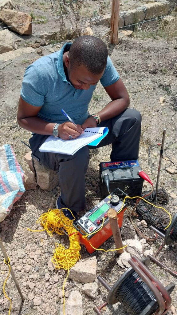
A VES survey uses four electrodes placed in a line on the ground:
- Two current electrodes (A and B) inject a controlled electric current into the ground.
- Two potential electrodes (M and N) measure the resulting voltage difference.
From the current, voltage and electrode geometry, the instrument calculates an apparent resistivity. By gradually increasing the spacing between the current electrodes while keeping the centre point fixed, the current penetrates deeper, so the apparent resistivity reflects deeper layers. Plotting apparent resistivity against electrode spacing produces a sounding curve.
The common electrode arrangement for groundwater VES is the Schlumberger array, in which the potential electrodes stay close together at the centre and the current electrodes are moved outward in steps. The Wenner array and dipole-dipole arrays are also used, particularly for profiling and imaging.
A rule of thumb is that the depth of investigation is roughly one-third to one-half of the half-spacing between the current electrodes (AB/2), depending on ground conditions. To investigate 100 metres depth, surveyors may need AB/2 values of several hundred metres, which requires adequate open space.
From Curve to Layers: Interpretation
The sounding curve is interpreted by inversion, a mathematical process that finds a layered model (thickness and resistivity of each layer) that best reproduces the field data. Software such as IPI2Win, Res1D or similar packages is commonly used. The output is a geoelectric section with, for example:
- Layer 1: dry topsoil, high resistivity, 1 to 3 m thick.
- Layer 2: weathered rock, moderate resistivity, 10 to 25 m thick.
- Layer 3: fractured rock or aquifer, lower resistivity, 20 to 60 m thick.
- Layer 4: fresh basement or massive lava, very high resistivity.
The hydrogeologist then links the geoelectric layers to the geology. Layer 3 in this example may be the target aquifer. The expected borehole depth would be through that layer and some distance below it.
Resistivity Profiling and 2D Imaging
Besides VES, surveyors use:
- Constant-spread profiling: moving a fixed array along a line to detect lateral changes, which is useful for finding fracture zones in hard rock. A pronounced low-resistivity anomaly may indicate a water-bearing fracture.
- Electrical resistivity tomography (ERT): multi-electrode systems that acquire many measurements automatically to produce a 2D cross-section image. ERT provides richer, more detailed pictures than single soundings, though it costs more.
For siting boreholes in fractured basement terrain, profiling followed by VES at anomalies is a common and efficient strategy.
Field Procedure in Practice
- Plan lines and stations using geology, lineaments and site constraints.
- Set out the array with tape, stakes and electrodes, ensuring good ground contact. In dry soil, watering electrodes can improve contact.
- Measure and record current, voltage and spacing at each step.
- Check data quality on site by plotting the curve, repeating noisy readings and looking for obvious errors.
- Record GPS coordinates of each station and notes on surface geology, topography and nearby features.
- Process and interpret the data back at the office, calibrating with local borehole logs where available.
A typical single VES station can be completed in a few hours depending on maximum spacing and terrain.
What Resistivity Can Tell You About a Borehole Site
- Depth to water-bearing layers.
- Thickness of weathered zone, which is often a key aquifer in basement terrain.
- Presence of fractures or fault zones.
- Clay content, since thick clay layers reduce yield.
- Relative water quality, since very low resistivities can flag saline zones, though this must be confirmed by chemistry.
- Depth to bedrock, important for estimating total drilling depth.
Limitations and Pitfalls
Honest practitioners explain that resistivity has limits:
Ambiguity (non-uniqueness). Different layered models can produce similar curves. Geological knowledge and borehole data help constrain the solution.
Clay versus water. Both lower resistivity. A thick low-resistivity layer may be clay with poor yield. This is the most common interpretation mistake.
Saline versus fresh water. Salty water gives very low resistivity. In arid and coastal areas, a low value may signal saline groundwater unsuitable for use.
Lateral heterogeneity. In volcanic and fractured terrains, conditions change within metres, so a single sounding may not represent the surroundings.
Noise and infrastructure. Metal fences, pipelines, power lines and buried cables can distort readings.
Limited depth. Reaching depths of 150 to 250 metres with conventional VES requires long electrode spreads. Space constraints in urban areas can limit what is possible, and ERT or other methods may be used.
Equivalence. Thin layers may be poorly resolved because of mathematical equivalence in the inversion.
Because of these limits, VES should never be used alone. It should be integrated with geology, remote sensing and local borehole data.
Kenyan Geological Settings and Resistivity Patterns
Nairobi and surrounding volcanic terrain. Layers of lava, tuff and clay-rich paleosols produce complex geoelectric sections. Productive zones can be thin and separated by low-permeability horizons, so calibration against nearby borehole logs is essential.
Rift floor (Nakuru, Naivasha, Baringo). Lacustrine sediments and evaporative conditions can cause low resistivities from clays and mineralised water, so quality must be assessed.
Basement terrain (Machakos, Kitui, parts of Western Kenya). Typically a high-resistivity fresh basement overlain by a weathered layer. The weathered zone and fracture anomalies are targets, and lateral profiling is valuable.
Northern and north-eastern sedimentary basins. Thick sedimentary sequences with variable salinity. Resistivity helps map fresh versus saline layers.
How to Judge the Quality of a VES Report
A good report should include:
- A site map with station coordinates and survey lines.
- Field data tables or curves and the processing method.
- Interpreted geoelectric sections with layer resistivities and thicknesses.
- The geological interpretation, explaining how resistivity layers were linked to rock types.
- A recommended drilling point with expected depth range, yield potential and quality risks.
- A statement of limitations and uncertainty.
- Calibration with nearby boreholes where possible.
If a “survey” consists of a single reading and a verbal recommendation, treat it with caution.
How Geophysics Fits Into Permit Applications
Because the Water Resources Authority expects hydrogeological reports to support drilling applications, resistivity results are commonly included as technical evidence. They show that the proposed site was chosen on scientific grounds. Our articles on the borehole permit process and on survey costs show where this fits in the overall workflow.
Cost Considerations
Geophysical surveys vary in price depending on number of stations, depth of investigation and method. A basic VES-based survey with report may form part of a KSh 50,000 to KSh 150,000 hydrogeological package, while more advanced ERT or multi-method surveys can cost more. The cost is small compared with drilling expenses, and it improves decisions on both location and depth.
Frequently Asked Questions
Does low resistivity always mean water? No. It can also indicate clay or saline conditions. Interpretation must include geology.
How deep can VES see? With sufficiently long electrode spacing, hundreds of metres, but resolution decreases with depth. Practical depth is often limited by available space.
How many VES stations do I need? At least one at each candidate site, and often several along a profile. More stations give better confidence.
Can VES guarantee water? No. It reduces risk but cannot eliminate it, particularly in fractured rock where success depends on intersecting a narrow fracture.
What is the best time to do a survey? Resistivity can be measured any time, but extremely dry or wet conditions affect electrode contact and near-surface readings, so experienced surveyors adjust their procedures.
Conclusion
Electrical resistivity, and VES in particular, is a proven, cost-effective tool for borehole siting in Kenya. By measuring how the ground resists electric current, geophysicists estimate the thickness and nature of subsurface layers and pinpoint likely aquifers. The method works best when combined with geological mapping, structural analysis and local borehole data, and when interpreted by someone who understands both its power and its limits.
For geophysical surveys and borehole siting you can rely on, contact Reg. Geol. Mbugua Githae (MGSK) via consult.innercoregeoconsultants.co.ke.