Skip to content
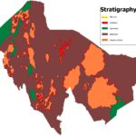
Mapping rock types across large, remote, or poorly exposed terrain has traditionally been slow, expensive work — requiring extensive fieldwork, careful sample collection, and painstaking manual interpretation of imagery. Machine learning is changing this workflow, allowing geologists to automate much of the initial lithological classification process using satellite data, dramatically expanding how much ground can be characterized before committing to expensive field campaigns.
This article explains how automated lithological classification works, the data and techniques behind it, and where it fits into a responsible exploration or mapping workflow.
What Is Lithological Classification?
Lithological classification is the process of identifying and mapping different rock types across a landscape — distinguishing, for example, between granite, basalt, sandstone, or limestone based on their physical and spectral characteristics. This is foundational to nearly every geological study, since rock type informs everything from mineral exploration targeting to geotechnical assessment to geological hazard evaluation.
Traditionally, lithological mapping has relied heavily on field geologists walking the ground, examining outcrops, and manually compiling geological maps — a process that’s thorough but slow and expensive, particularly across large or difficult-to-access terrain. Satellite-based classification, especially when combined with machine learning, offers a way to generate a strong preliminary lithological map remotely, focusing expensive field time on verification and refinement rather than blind reconnaissance.
How Machine Learning Enables Automated Classification
Spectral Signatures as Classification Input
Different rock types reflect and absorb electromagnetic energy differently based on their mineral composition, creating distinct spectral signatures that can be captured by multispectral and hyperspectral satellite sensors. Traditional classification approaches used relatively simple statistical methods — band ratios, principal component analysis — to distinguish these signatures. Machine learning models can learn far more complex, non-linear relationships between spectral data and rock type, often achieving meaningfully better classification accuracy, particularly in geologically complex areas with subtle spectral differences between units.
Training Data Requirements
Supervised machine learning classification requires labeled training data — locations where the rock type is already known, either from existing geological maps, field verification, or drill core data. The model learns the spectral characteristics associated with each rock type from these labeled examples, then applies that learned pattern to classify unlabeled areas across the rest of the study region.
The quality and representativeness of this training data significantly affects classification accuracy. A model trained only on well-exposed outcrop in one part of a study area may not generalize well to areas with different weathering conditions, vegetation cover, or subtle lithological variations — a limitation that responsible practitioners need to account for when designing a classification program.
Incorporating Multiple Data Layers
The most effective lithological classification models don’t rely on spectral data alone. Combining satellite imagery with terrain-derived data (slope, elevation, terrain roughness), geophysical data (magnetic or radiometric surveys), and existing geological knowledge typically produces substantially more accurate results than spectral classification in isolation, since rock type often correlates with terrain expression and geophysical response in ways that add valuable, independent information to the classification.
Common Machine Learning Approaches
Several machine learning techniques are commonly applied to lithological classification, each with different strengths:
- Random forest and gradient boosting models are widely used for their strong performance on structured, multi-layer geospatial data and their relative interpretability compared to deep learning approaches.
- Support vector machines have a long track record in remote sensing classification and remain a solid choice, particularly for well-defined classification problems with clear spectral separation between classes.
- Convolutional neural networks are increasingly applied where spatial context — not just per-pixel spectral values — matters for classification accuracy, since these models can learn to recognize textural and spatial patterns associated with specific rock types or geological structures.
Practical Applications
Regional Geological Mapping
In frontier or poorly mapped regions, automated lithological classification can generate a preliminary geological map far faster than traditional field-based mapping alone, providing a valuable starting framework that field geologists can verify, refine, and build upon rather than starting from a blank map.
Exploration Target Generation
Combined with structural and alteration mapping, automated lithological classification helps exploration teams identify favorable host rock units across large areas, supporting early-stage target generation before committing to detailed, resource-intensive field programs.
Updating and Refining Existing Geological Maps
Many regions have geological maps that are decades old, compiled at coarse scale, or based on limited field verification. Automated classification using modern satellite data can help identify areas where existing maps may need updating, flagging discrepancies between mapped and predicted lithology for field verification.
Supporting Infrastructure and Geotechnical Planning
For linear infrastructure projects spanning large and variable terrain, automated lithological classification can provide an efficient first-pass understanding of geological conditions along a proposed route, helping prioritize where more detailed geotechnical investigation is warranted.
Limitations to Understand
Vegetation and soil cover. In densely vegetated or heavily weathered terrain, surface spectral signatures may reflect vegetation or soil characteristics rather than underlying bedrock, significantly limiting classification accuracy. This is a persistent challenge in tropical and heavily weathered regions in particular.
Spectral similarity between rock types. Some lithologically distinct rock units have similar spectral signatures, particularly where weathering products are similar despite different parent rock composition, making them difficult to distinguish through spectral classification alone.
Training data bias. Classification accuracy depends heavily on how representative the training data is of the full range of conditions across the study area. Models trained on limited or non-representative training data can produce misleadingly confident but inaccurate results across areas with different conditions.
Boundary precision. Automated classification often struggles with precise geological contact placement, since real geological boundaries can be gradational or complex in ways that don’t always align cleanly with classification model outputs.
Integrating Automated Classification into a Field Workflow
The most effective use of automated lithological classification treats it as a powerful first-pass tool rather than a final geological map. A typical workflow might look like:
- Compile available data — existing geological maps, satellite imagery, terrain data, geophysical surveys, and any prior field observations.
- Train and apply a classification model using available labeled data, producing a preliminary lithological map across the study area.
- Identify areas of model uncertainty or disagreement with existing geological knowledge, prioritizing these for field verification.
- Conduct targeted field mapping to verify and refine the automated classification, focusing effort where it adds the most value rather than attempting comprehensive ground coverage.
- Update and retrain the model with new field data, improving accuracy for future classification in similar terrain.
This iterative approach captures the efficiency benefits of automated classification while maintaining the geological rigor that only experienced field verification can provide.
Getting Reliable Results
Automated lithological classification is a genuinely powerful tool for expanding geological mapping coverage and efficiency, but it requires careful implementation — appropriate data selection, representative training data, and realistic expectations about accuracy and limitations. An experienced geoconsulting team can help design a classification approach suited to your specific terrain, target geology, and project stage, and can ensure results are properly validated before they inform significant exploration or planning decisions.
Interested in accelerating your geological mapping program with satellite-based classification? Contact our team to discuss an approach tailored to your project area.