Skip to content
Vegetation has always been the enemy of geological mapping. Dense forest canopy can hide fault scarps, landslide scars, and outcrops that would otherwise be obvious from the air — forcing geologists to rely on slow, expensive, and sometimes dangerous ground traverses to fill in the gaps. LiDAR has largely solved this problem, giving geoscientists the ability to see through vegetation and generate bare-earth terrain models with a level of detail that was simply unavailable a generation ago.
This article looks at how LiDAR works, why it’s become indispensable for geological mapping, and where it delivers the most value in a modern geoconsulting workflow.
What Is LiDAR?
LiDAR — Light Detection and Ranging — works by emitting rapid pulses of laser light toward the ground and measuring the time it takes for each pulse to return. Because the speed of light is constant, that return time can be converted into a precise distance measurement. A LiDAR sensor mounted on an aircraft, drone, or satellite fires hundreds of thousands of pulses per second, building up a dense three-dimensional point cloud of the surface below.
Crucially, some of these laser pulses penetrate gaps in vegetation canopy and reflect off the actual ground surface beneath. By isolating these “last return” or ground-classified points and filtering out returns from tree canopy, buildings, and other surface clutter, LiDAR processing software can generate a bare-earth digital terrain model (DTM) that reveals the true ground surface — even in areas with dense forest cover.
Why LiDAR Matters for Geology
Traditional aerial photography and even most satellite imagery only capture what’s visible from above — the tops of trees, not the ground beneath them. In heavily vegetated terrain, this means large portions of the landscape are effectively invisible to conventional mapping techniques.
LiDAR changes that. By stripping away vegetation computationally, geologists gain access to fine-scale topographic detail — subtle scarps, drainage patterns, structural lineaments, and landform features — that would otherwise require painstaking, often impractical fieldwork to identify. This has made LiDAR one of the most transformative tools in structural geology, geohazard assessment, and terrain-based exploration over the past two decades.
Key Applications in Geological Work
Fault and Structural Mapping
Active fault traces often express themselves at the surface as subtle topographic features — small scarps, offset stream channels, sag ponds — that can be nearly impossible to spot in forested or brush-covered terrain using aerial photography alone. High-resolution LiDAR-derived hillshade and slope models make these features stand out clearly, which is why LiDAR has become a standard tool in seismic hazard studies and active fault mapping programs worldwide.
Landslide Identification and Susceptibility Mapping
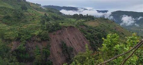
Landslides leave distinctive topographic signatures — head scarps, hummocky terrain, toe bulges — that are often obscured by vegetation in optical imagery but clearly visible in bare-earth LiDAR models. This makes LiDAR extremely effective for identifying both active and historical landslides across large areas, supporting landslide inventory mapping and susceptibility modeling for transportation corridors, hillside developments, and forestry operations.
Geomorphological and Drainage Analysis
Fine-resolution terrain models allow geologists to extract precise drainage networks, catchment boundaries, and geomorphic features that inform everything from flood risk modeling to understanding long-term landscape evolution. This level of detail supports more accurate hydrological modeling than is possible with coarser, satellite-derived elevation data.
Outcrop and Structural Data Extraction
Terrestrial and drone-based LiDAR scanning of rock outcrops can capture highly detailed 3D models of exposed geology, allowing geologists to measure bedding orientations, fracture patterns, and fold geometries remotely and with survey-grade accuracy. This is particularly valuable for steep or inaccessible outcrops — cliff faces, quarry walls, road cuts — where traditional compass-and-clipboard mapping would be difficult or unsafe.
Mine Planning and Volumetric Analysis
In active mining operations, LiDAR is widely used to generate accurate topographic surveys for pit design, waste rock dump monitoring, and stockpile volume calculations. Repeat LiDAR surveys over time also support change detection, helping operators track material movement and monitor for signs of slope instability.
Infrastructure and Geohazard Risk Assessment
For linear infrastructure — pipelines, roads, rail corridors, transmission lines — LiDAR-derived terrain models are used to assess geohazard exposure along the entire route, identifying areas prone to landslides, erosion, or flooding well before construction begins.
Airborne vs. Terrestrial vs. Drone-Based LiDAR
Not all LiDAR is deployed the same way, and the right platform depends heavily on project scale and the level of detail required.
Airborne LiDAR, typically flown from a fixed-wing aircraft or helicopter, covers large areas efficiently and is the standard choice for regional-scale mapping projects — fault studies, landslide inventories, watershed-scale terrain analysis.
Drone-based LiDAR has grown rapidly in recent years, offering higher point density and finer resolution over smaller areas at a lower cost than traditional airborne surveys. This makes it well suited to site-specific investigations, mine sites, and infrastructure corridors where finer detail justifies the more limited coverage area.
Terrestrial LiDAR, whether handheld, tripod-mounted, or vehicle-based, delivers the highest resolution of all, capturing millimeter-scale detail on outcrops, rock faces, and engineered structures. It’s the tool of choice when structural geologists need precise, survey-grade measurements of specific features.
Processing Considerations
Raw LiDAR point clouds require substantial processing before they’re useful for geological interpretation. Ground classification algorithms need to correctly distinguish bare-earth returns from vegetation and structures — a step that’s more challenging in areas with dense, multi-layered canopy or complex terrain. Point cloud density, flight altitude, and pulse rate all affect the final resolution and accuracy of the derived terrain model, and these parameters should be specified based on the geological features the survey is intended to capture.
Once classified, terrain models are typically visualized using hillshade renderings, slope maps, and curvature analysis — techniques that enhance subtle topographic features and make structural and geomorphic patterns easier to identify, whether through manual interpretation or automated feature extraction.
Integrating LiDAR with Other Datasets
LiDAR delivers the most value when combined with complementary data sources. Draping satellite or aerial imagery over a LiDAR-derived terrain model helps correlate surface color and spectral characteristics with terrain features. Pairing LiDAR with geophysical or geochemical survey data helps confirm whether topographically identified structures correspond to genuine subsurface features. And integrating LiDAR-based landslide or fault inventories into GIS platforms allows this data to directly inform hazard modeling, land use planning, and engineering design decisions.
Getting the Most from a LiDAR Survey
LiDAR is a powerful tool, but its value depends heavily on how the survey is designed and processed. Point density requirements, flight planning, ground classification methodology, and interpretation approach should all be tailored to the specific geological questions the project needs to answer — a regional fault reconnaissance study has very different requirements than a detailed slope stability assessment for a single site.
Working with an experienced geoconsulting team ensures the survey is scoped correctly from the outset, avoiding the common pitfall of acquiring expensive data that doesn’t ultimately answer the geological question at hand.
Considering LiDAR for an upcoming mapping, hazard assessment, or exploration project? Contact our team to discuss the right survey approach for your terrain and objectives.