Skip to content
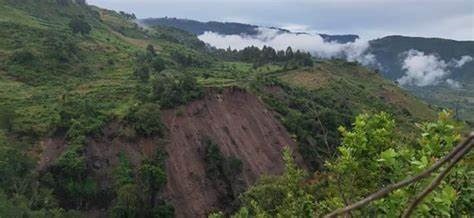
Ground doesn’t usually move fast enough for people to notice — a few centimeters a year is invisible to the naked eye, easy to dismiss until cracked foundations, damaged pipelines, or flooded low-lying areas make the consequences impossible to ignore. InSAR, a satellite radar technique capable of detecting millimeter-scale ground movement, has become one of the most important tools available for catching subsidence and deformation long before it becomes a visible problem.
What InSAR Is and How It Works
InSAR stands for Interferometric Synthetic Aperture Radar. The technique works by comparing two or more radar images of the same location, taken by satellite at different times, and analyzing the phase difference between the radar signals that bounced back from the ground. Because radar wavelengths are known with extreme precision, even tiny changes in the distance between the satellite and the ground surface — caused by the ground moving toward or away from the satellite between image acquisitions — show up as measurable phase shifts.
The result is a deformation map capable of detecting ground movement at the millimeter to centimeter scale, across areas from a single site to entire countries, using data from satellites that already pass over most of the planet on a regular repeat cycle. Missions like the European Space Agency’s Sentinel-1 constellation provide freely available radar data with repeat coverage of roughly six to twelve days over most of the globe, making time-series deformation monitoring increasingly accessible even for organizations without their own satellite tasking budget.
What Causes Land Subsidence
Subsidence has several distinct causes, and correctly identifying which one is driving movement at a given site is essential for choosing an appropriate response.
Groundwater extraction — when water is pumped from an aquifer faster than it naturally recharges, the reduction in pore pressure can cause compaction of fine-grained sediment layers, particularly in unconsolidated basin sediments. This is one of the most common and often most severe causes of subsidence worldwide, and it’s frequently associated with rapidly growing urban areas relying heavily on groundwater.
Mining-related subsidence — underground mining, and to a lesser extent large-scale open-pit operations, can cause ground settlement above and around excavated areas as rock adjusts to the removal of subsurface material.
Geothermal fluid extraction — similar to groundwater pumping, extracting geothermal fluids without adequate reinjection can reduce reservoir pressure and cause measurable surface subsidence over producing geothermal fields, making subsidence monitoring a standard component of responsible geothermal field management.
Natural geological processes — tectonic subsidence, sediment compaction in young deltaic or lacustrine deposits, and volcanic deflation (as magma chambers empty or pressurize) can all produce InSAR-detectable deformation independent of human activity.
Construction and loading effects — large structures placed on compressible soils can cause localized settlement, which InSAR can track over the structure’s operational lifetime.
Reading an InSAR Deformation Map
InSAR outputs are typically displayed as color-coded maps, where each color band represents a specific increment of ground movement toward or away from the satellite (often shown as concentric “fringes” in raw interferograms, or as smoothed color gradients in processed time-series products). Areas showing consistent, progressive color change across a time series indicate ongoing deformation, while stable areas show no significant color pattern over time. Time-series analysis — tracking deformation across many image pairs rather than just two — is generally far more reliable than single-interferogram analysis, since it can distinguish genuine ground movement trends from atmospheric noise and other short-term artifacts that affect individual radar acquisitions.
Applications Across Mining, Geothermal, and Urban Sectors
Mining — InSAR provides an efficient way to monitor subsidence around underground and open-pit operations over time, complementing ground-based monitoring instruments and providing early warning of areas experiencing accelerating deformation that may need closer geotechnical attention.
Geothermal energy — Reservoir pressure management is central to sustainable geothermal field operation, and InSAR-derived subsidence data provides an independent, spatially continuous check on reservoir behavior, helping operators evaluate whether reinjection strategies are adequately maintaining reservoir pressure across the full extent of a producing field, not just at monitored well locations.
Urban planning and infrastructure — Rapidly urbanizing areas reliant on groundwater are particularly vulnerable to subsidence-related infrastructure damage. InSAR time-series analysis over cities allows planners to identify areas of concern before major infrastructure damage occurs, supporting more informed decisions about groundwater management, zoning, and infrastructure design in vulnerable zones.
Relevance to East African Applications
The technique has direct relevance across several of East Africa’s key sectors: geothermal fields along the Rift Valley, where subsidence monitoring supports sustainable reservoir management; rapidly growing urban centers with expanding groundwater dependence; and active or historic mining areas where subsidence risk needs ongoing assessment. Because Sentinel-1 provides free, regularly repeating coverage across the region, the primary barrier to wider InSAR adoption locally tends to be technical processing capacity and interpretation expertise rather than data access itself — a gap that’s increasingly addressable as processing tools and cloud-based platforms become more accessible.
Practical Considerations for Implementation
InSAR is not without limitations worth understanding before relying on it. Dense vegetation cover can degrade radar coherence, reducing measurement reliability in heavily forested areas. Atmospheric water vapor introduces noise that must be corrected for, particularly in humid tropical climates. And InSAR measures deformation along the satellite’s line of sight, meaning purely horizontal movement can be under-detected unless data from multiple viewing geometries is combined. None of these limitations make InSAR unreliable — they simply mean results should be interpreted by someone with genuine expertise in radar processing, rather than treated as an automatic, plug-and-play output.
The Bottom Line
InSAR has turned land deformation monitoring from an expensive, sparse, point-based measurement problem into a continuous, wide-area, satellite-based capability. For any organization managing groundwater resources, mining operations, or geothermal fields, incorporating InSAR-based subsidence monitoring into routine operations is no longer a cutting-edge novelty — it’s rapidly becoming standard practice, and one of the more cost-effective risk management tools available in the modern geoscience toolkit.