Skip to content

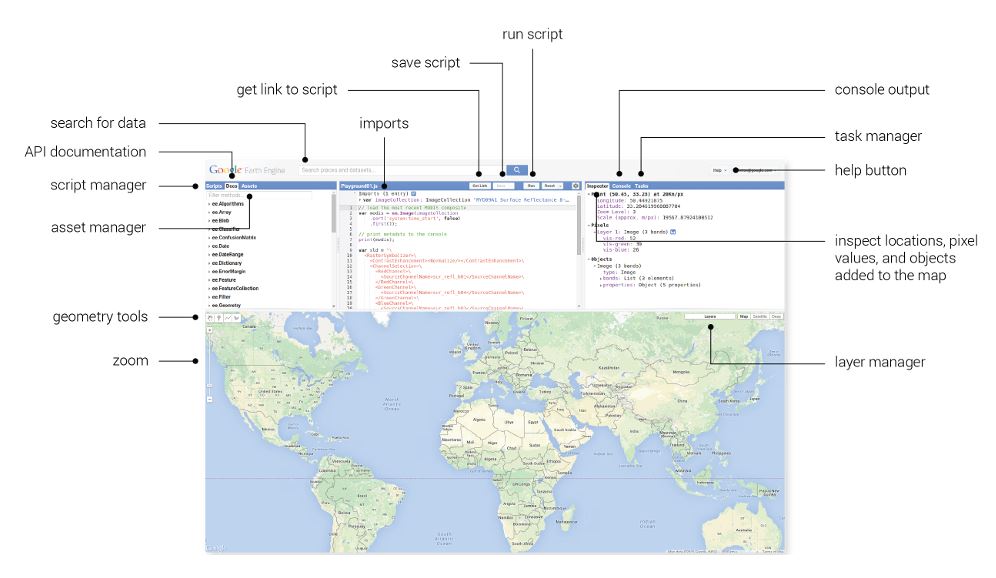
Google Earth Engine (GEE) is a cloud-based geospatial analysis platform. It combines a multi-petabyte catalogue of satellite imagery and geospatial datasets with Google’s computing infrastructure, so that you can analyse planet-scale data without downloading it to your own computer. You write short scripts in JavaScript (Code Editor) or Python (Earth Engine API), the processing runs on Google’s servers, and you view results on a map, export them or use them in other software.
For geologists, this solves several practical problems. Traditionally, working with Landsat or Sentinel imagery meant downloading large scenes, correcting them, mosaicking tiles, masking clouds and processing on a local machine, which is slow in places with limited bandwidth and computing power. Earth Engine does the heavy lifting in the cloud and lets you work across entire countries or decades of imagery with a few lines of code.
Licensing note. Earth Engine has been free for many research, education and non-commercial uses, while commercial use is subject to paid plans and terms that Google can update. Always check the current terms of service and registration requirements before using it for commercial client work.
What Data Can You Access?
The Earth Engine data catalogue includes many datasets relevant to geology:
- Landsat archive (multiple missions, from the 1980s onward in many regions), including surface reflectance products.
- Sentinel-2 multispectral imagery (10, 20 and 60 m bands) and Sentinel-1 radar imagery.
- ASTER data products (check availability and the status of SWIR bands in the archive for your area and period).
- Digital elevation models, including SRTM, ALOS and other global DEMs.
- MODIS and other coarse-resolution products for land surface temperature, vegetation and regional studies.
- Climate and hydrology datasets: rainfall (such as CHIRPS), evapotranspiration, soil moisture and groundwater-related products.
- Land cover and land use maps, water body maps and surface water occurrence.
- Gravity, magnetic and geology-related datasets in some cases, and user-uploaded vector or raster data (assets).
You can also upload your own data, such as concession boundaries, sample locations, geological polygons and geochemical points, and combine them with the global catalogue.
Why Earth Engine Suits Geological Work
- Scale. Process entire licence areas, countries or basins.
- Time series. Analyse change over decades, useful for mining footprint, erosion, vegetation dynamics, surface water and ground deformation proxies.
- No data downloads or heavy hardware. All you need is a browser and an internet connection.
- Cloud masking and compositing. Create cloud-free composites by combining many images, which is especially valuable in humid or seasonally cloudy regions.
- Speed. Operations that take hours locally can run in minutes.
- Reproducibility. Scripts document your workflow and can be shared and rerun.
- Integration. Export results as GeoTIFF or vector files for QGIS, ArcGIS or other geological software.
- Low barrier to entry. The Code Editor and an extensive community and documentation help beginners.
Core Concepts You Need to Know
Image and ImageCollection. An Image is a single raster with bands. An ImageCollection is a stack of images, such as all Sentinel-2 scenes over an area for a year.
Feature and FeatureCollection. Vector data, such as points, lines and polygons with attributes.
Geometry and region of interest. You define your study area by drawing on the map, importing a boundary or using coordinates.
Filtering. You filter collections by date, area and metadata, for example by cloud cover percentage.
Reducers. Operations that summarise data, such as taking the median of a time series per pixel, computing statistics over polygons or combining bands.
Mapping functions. Applying the same function (such as calculating an index) to every image in a collection.
Client and server. Earth Engine code builds instructions that run on Google’s servers. Understanding this distinction helps you write efficient code and avoid common errors.
Export. Sending results to Google Drive, Cloud Storage or Earth Engine assets.
Geological Applications
1. Lithological and alteration mapping with band ratios and indices. Using Sentinel-2 or Landsat surface reflectance, you can compute ratios that highlight iron oxides and clay or hydroxyl minerals, for example:
- A ratio of red to blue for ferric iron oxides.
- A ratio of SWIR1 to SWIR2 for hydroxyl and clay-bearing minerals.
- A ratio of SWIR to NIR for ferrous minerals.
In Earth Engine, you create a cloud-free median composite for the dry season, calculate the ratios with simple band maths, stretch the values and display a false-colour composite, then export the results. Exact band numbers differ between sensors, so check the band definitions for the dataset you use. See our article on remote sensing for mineral exploration for the geological reasoning behind these ratios.
2. Principal component analysis and spectral enhancement. Earth Engine supports statistical operations such as principal component analysis on image bands, allowing you to apply feature-oriented techniques for alteration mapping over large areas.
3. Structural mapping and lineament analysis. Load a DEM, generate multi-azimuth hillshades, and compute slope, aspect and curvature, or apply filters to enhance linear features. Export the enhanced layers to QGIS for manual or automated lineament digitising. This is a quick way to screen very large areas before detailed work. See our lineament extraction article.
4. Mineral exploration targeting and prospectivity inputs. Earth Engine can generate evidence layers such as alteration indices, vegetation anomalies, drainage density and distance to structures, which feed into prospectivity models built in Python or R. Earth Engine also supports machine learning (such as random forests) directly, and you can classify surface materials using training polygons. Remember the validation and bias issues discussed in our prospectivity mapping article.
5. Hydrogeology and groundwater studies. Combine rainfall time series, soil moisture, evapotranspiration, land cover, slope, drainage density and lineaments to build groundwater potential or recharge indicator maps. Time series of vegetation and surface water show seasonal dynamics that hint at groundwater-dependent ecosystems and recharge zones. You can also monitor lake and reservoir extent changes, which relate to hydrological conditions. See our groundwater potential mapping article.
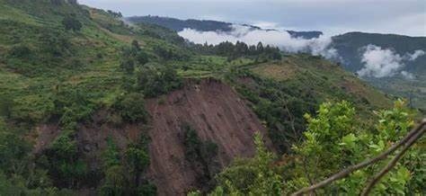
6. Hazard and geotechnical screening. Terrain analysis for landslide susceptibility factors (slope, curvature, drainage), flood extent mapping with radar (Sentinel-1 is useful because it sees through cloud), and land cover change detection. Earth Engine is a useful screening tool, with local validation for decisions.
7. Monitoring mining and environmental change. Detect mine footprint expansion, tailings and waste dump changes, vegetation recovery after rehabilitation, artisanal mining activity and water quality indicators in surface water. Time series analysis supports environmental compliance and closure planning.
8. Geothermal and thermal studies. Land surface temperature products from Landsat thermal bands and MODIS help screen for thermal anomalies, in combination with structural and geological data.
9. Regional geology and landform mapping. Compute geomorphological indices, classify landforms, map drainage networks and delineate catchments for context in geological interpretation.
10. Time series and change detection. Compare images across years to map landslides, shoreline change, erosion, dune movement, flooding and land degradation.
A Step-by-Step Workflow Example: Iron Oxide and Clay Alteration Screening
This outline shows the logic. Check the current Earth Engine documentation for exact dataset names, band names and syntax before running anything.
Step 1: Get access. Sign up for Earth Engine with a Google account and agree to the terms. Open the Code Editor (browser-based) or set up the Python API.
Step 2: Define the study area. Draw a polygon over your licence or import a boundary as an asset.
Step 3: Select imagery. Choose the Sentinel-2 surface reflectance collection. Filter by your study area, by date range (for example the dry season of one or more years) and by a cloud cover threshold.
Step 4: Mask clouds and shadows. Apply a cloud mask using the quality information bands provided with the dataset, or a cloud probability product. This is critical to avoid spurious anomalies.
Step 5: Create a composite. Reduce the collection with a median to produce a clean, representative image.
Step 6: Mask unwanted surfaces. Remove vegetation (using an index such as NDVI with a threshold), water and built-up areas so that the analysis focuses on exposed soil and rock.
Step 7: Compute band ratios. Calculate the iron oxide and clay ratios using the appropriate bands for the sensor.
Step 8: Visualise. Display the ratios as colour channels and adjust the stretch. Compare with geological maps and known mineral occurrences.
Step 9: Threshold and extract anomalies. Classify high ratio values and vectorise the results, if desired.
Step 10: Export. Send the composite, ratio images and anomaly polygons to Google Drive as GeoTIFF or shapefile and continue in QGIS to combine with structure, geology, geochemistry and geophysics.
Step 11: Validate in the field. Check anomalies on the ground, since false positives from soils, burnt areas and cultural features are common.
Best Practices
- Start with a clear question and the geological model behind it.
- Use surface reflectance data for consistent analysis, and carefully mask clouds.
- Choose appropriate seasons. Dry-season imagery with minimal vegetation is usually best for geology.
- Use composites and statistics rather than single scenes, to reduce noise.
- Keep scripts organised and commented, and save versions.
- Check scale and resolution when exporting and analysing. The native scale of the data should guide your work.
- Be mindful of computation limits. Very large or complex operations can time out, so test on a small area first and use efficient methods.
- Validate with ground data and independent datasets.
- Document sources and methods, including dataset versions.
- Respect licences of datasets and the platform, especially for commercial projects.
Limitations and Cautions
- Spectral and spatial resolution. Freely available multispectral data have limited ability to discriminate similar minerals and cannot see beneath cover.
- Surface cover. Vegetation, soil and weathering can mask bedrock signatures.
- ASTER and other sensor limitations. Check the availability, quality and coverage of specific datasets for your area.
- False positives. Remote sensing anomalies need geological interpretation and field checks.
- Learning curve. Writing code requires some programming skills and understanding of Earth Engine’s server-side model.
- Dependency on a platform. Terms, quotas and features can change, so keep local copies of key results and consider alternatives for critical workflows.
- Data privacy. Uploading confidential exploration data to a cloud platform requires careful consideration of confidentiality and company policy.
- Not a replacement for specialised software. Earth Engine complements, rather than replaces, tools for geophysical processing, 3D modelling and detailed hyperspectral analysis.
- Reporting standards. Remote sensing outputs are exploration aids and should not be presented as proof of mineralisation.
Complementary Tools
Earth Engine works best as part of a broader toolkit:
- QGIS for detailed mapping, editing, layouts and integration with geological data. See our article on free GIS software.
- Python and R for statistics and machine learning (and the Earth Engine Python API, geemap and related libraries to streamline workflows).
- ESA SNAP for specialised radar and Sentinel processing.
- Geophysical software for magnetic and radiometric data.
- Drone data tools for local high-resolution mapping.
Learning Path for Geologists
- Learn the basics of remote sensing (bands, reflectance, indices).
- Complete the Earth Engine beginner tutorials and explore example scripts for Landsat and Sentinel-2.
- Practise on a familiar area where you know the geology.
- Reproduce known results, such as an iron oxide map over a known gossan.
- Add DEM analysis and time series.
- Learn Python and the Earth Engine Python API for automation and machine learning.
- Join the community forums to ask questions and review shared scripts.
- Always validate with geological and field data.
Frequently Asked Questions
Do I need to know how to code? Basic coding helps considerably, since Earth Engine is script-based. Many examples and tutorials exist, and you can start by adapting existing scripts.
Is Earth Engine free? It has been free for many non-commercial and research uses, with paid options for commercial use. Check the current terms.
Can Earth Engine find minerals? No. It helps map surface features such as alteration, lithology and structure, which are indirect indicators that need geological interpretation and follow-up.
What resolution can I get? Typically 10 to 30 m for Sentinel-2 and Landsat. Commercial high-resolution data may be available in some cases, subject to terms.
Can I use my own geological data inside Earth Engine? Yes, you can upload vector and raster assets and combine them with the public catalogue.
How is it different from QGIS? QGIS is a desktop GIS for detailed local work, while Earth Engine is a cloud platform for large-scale satellite analysis. They complement each other.
Conclusion
Google Earth Engine gives geologists access to planetary-scale satellite data and cloud computing, making regional alteration mapping, structural screening, groundwater studies, hazard assessment and environmental monitoring faster and more repeatable. Used with sound geological reasoning, careful masking and field validation, it is a powerful addition to the exploration and hydrogeology toolkit. Keep its limits in mind, and combine it with QGIS, geophysics and ground data for dependable results.
For remote sensing, GIS and data-driven geological interpretation, contact Reg. Geol. Mbugua Githae (MGSK) through consult.innercoregeoconsultants.co.ke.