Skip to content

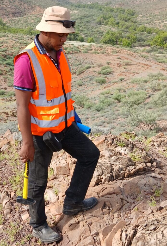
Method choice depends on the deposit type. Much African gold is orogenic gold, formed when hot, gold-bearing fluids moved through major faults and shear zones during mountain-building events and deposited gold in quartz veins and altered wall rock. The USGS describes these deposits as occurring mainly in granite-greenstone belts, controlled by large strike-slip and thrust fault systems, with carbonate alteration halos and an association with elements such as arsenic, tungsten and antimony. A greenstone belt is a belt of ancient, metamorphosed volcanic and sedimentary rocks, usually green because of minerals formed at low metamorphic grade.
Other targets include banded iron formation (BIF)-hosted gold, volcanogenic massive sulphide (VMS) deposits, and paleoplacers, which are ancient river or beach sediments with gold, as in the Witwatersrand in South Africa. Placer and alluvial gold in modern rivers is also widely worked by artisanal miners. Because deposit models drive exploration, the first step is always to decide which type is plausible in the area.
Geological mapping and structural analysis
Geological mapping remains the foundation. Geologists record rock types, veins, alteration, foliation and fault orientations, and build a picture of how structures could have controlled fluid flow. For orogenic gold, structural analysis is central: dilational jogs, fault bends, splays and the intersection of different structures often mark the places where fluids were focused.
In many African districts bedrock is hidden under soil, laterite or alluvium. A 2010 company report on a project in Kenya’s Migori area, for example, noted that several metres of alluvial cover had hindered geological mapping and concealed mineralised zones. In such cases explorers rely on indirect evidence: float (loose rock fragments), trenches, pits, and the workings of artisanal miners. Mapping of artisanal pits is valuable because it shows where veins reach the surface and what host rocks and alteration they follow. These workings are also sites where informal miners are active, so approach them with permission and care for safety and livelihoods.
Remote sensing and regional data
Satellite imagery and national datasets help screen large areas cheaply. Multispectral and radar imagery can highlight lineaments (linear features that may be faults), drainage patterns, and some alteration minerals where vegetation is sparse. Government geological surveys and earlier companies often hold maps, drill logs and geophysical data. In Kenya, a nationwide airborne mapping survey final report was unveiled in June 2022, according to press coverage, but the public availability and content of specific datasets should be confirmed with the relevant ministry or survey department before assuming they are free or suited for gold exploration.
Remote sensing does not find gold directly. It helps focus ground teams where structure and alteration look most favourable.
Stream-sediment, soil and rock geochemistry
Geochemistry is the measurement of chemical elements in samples. It is usually the first direct test for gold on the ground.
- Stream-sediment sampling collects material from drainages. A gold anomaly in a stream suggests a source somewhere upstream. It is efficient for regional work, but results need careful interpretation because sediment mixes material from the whole catchment.
- Soil sampling is done on grids or lines. In deeply weathered terrain, gold and associated elements may be redistributed, so sampling depth and horizon (for example, residual soil rather than transported cover) matter.
- Rock-chip and channel sampling collects bedrock directly, often from veins and trenches, to measure grades.
- Pathfinder elements such as arsenic, antimony, tungsten or bismuth may form wider halos than gold itself and can help vector toward mineralisation, depending on the deposit type.
Gold is difficult to sample because it can be coarse, patchy and unevenly distributed, a feature known as the nugget effect. Large sample sizes, careful laboratory methods such as fire assay, and quality control with standards and blanks are therefore essential. Reports by researchers working in Kenya’s Migori belt describe gold grain sizes that vary considerably between grain counts and weight, a reminder that apparent grades depend on how samples are prepared and measured.
Geophysics: seeing through cover
Geophysics uses physical measurements to infer geology. Several methods are common in gold exploration across Africa.
- Airborne magnetics measures variations in the Earth’s magnetic field caused by rocks. It can map faults, shear zones, dykes, iron-rich units and rock contacts. In Migori, a company programme in 2010 included an airborne magnetic survey intended to identify structures such as faults and shear zones.
- Radiometrics measures natural radiation from potassium, thorium and uranium and can help map lithology and some alteration, though transported soils and laterite can mislead. One published study of gold exploration in tropical Mali and Brazil noted that potassium readings from transported laterite unrelated to bedrock reduced the success of part of the radiometric interpretation.
- Induced polarisation (IP) and resistivity use electrical currents in the ground. IP responds to disseminated sulphide minerals, which often accompany gold, and resistivity can map quartz veins or clay-rich weathered zones.
- Gravity measures density differences and is used for regional structure and some intrusive bodies.
- Electromagnetic (EM) methods, including VLF-EM, help detect conductive structures.
A review of Newmont’s work in Ghana lists airborne magnetics, radiometrics and electromagnetics, and ground gravity, magnetics and IP/resistivity as part of an interdisciplinary approach that also includes geochemistry, regolith mapping and structural observation. The same abstract notes that Ghana’s major gold deposits, such as Obuasi and Tarkwa, were mostly found earlier by soil and stream-sediment sampling, trenching and drilling, which shows geophysics is a support tool and not a replacement for traditional methods.
Regolith: the challenge of deep tropical weathering
Across much of Africa, rocks are weathered to depths of tens of metres. The weathered cover, called regolith, includes soils, laterite crusts and saprolite (rotted bedrock). Regolith can both help and hinder. Weathering can concentrate gold near surface, creating oxide ore that is easy to process, but it can also bury geochemical signals under transported material.
Regolith mapping separates residual from transported cover so that samples and geophysical data are interpreted correctly. The case-study paper on gold under deep tropical weathering found that magnetics, IP and VLF-EM still gave useful information on lithology, structure and alteration despite thick laterite, but the authors also describe how transported material complicated radiometric results. Auger drilling, which collects samples from near the base of the soil, is often used to test geochemical anomalies in such terrains.
Trenching, pitting and drilling
When surface work indicates a target, direct sampling follows.
- Trenching and pitting expose bedrock for mapping and channel sampling. They are cheap and provide continuous information, but are limited by depth and by groundwater, and they require careful rehabilitation.
- Auger and aircore drilling are shallow, fast and used to test regolith and geochemical anomalies. A company in Kenya’s Migori belt reports using aircore and scout diamond drilling among a range of methods.
- Reverse circulation (RC) drilling gives many samples at moderate cost.
- Diamond (core) drilling produces core for geological logging, structural measurements and detailed assay, and is generally used for resource definition.
Drill programmes are designed so holes intersect structures at useful angles. Down-hole surveys, accurate collar positions, density measurements and sample QA/QC underpin any later resource estimate. Under internationally used reporting codes such as the JORC Code, public reporting of exploration results and resources is expected to be prepared by or under a Competent Person and follow principles of transparency and materiality.
Metallurgical testing and environmental baseline
Exploration does not end with a grade. Gold is recovered in different ways depending on how it occurs. Free gold may respond to gravity separation, while fine or refractory gold (locked in sulphides) may need cyanide leaching, flotation or roasting. Test work early in a project avoids the unpleasant surprise of a deposit with attractive grades but poor recoveries.
Research on artisanal processing in Kenya’s Migori belt shows why this matters. The authors report gold mainly as electrum, a gold-silver alloy, with most grains by count very fine, while most of the gold by weight is coarser, and they note that standard sluice-box and mercury methods lose much of the fine gold. That kind of information is valuable for both industrial and artisanal planning, and it also highlights the health and environmental problems linked to mercury use.
Environmental and social baseline work, such as water quality, ecology, land use, heritage and community mapping, begins alongside technical work. Legal frameworks, such as Kenya’s Mining Act, 2016, tie licence grants to environmental plans and landowner or community consent, so regulatory details should be confirmed with the relevant authority.
Integrating the data
No single method defines a gold target. Explorers build a 3D geological model that combines mapping, geochemistry, geophysics and drilling. They then rank targets by asking whether independent datasets agree: Does a soil anomaly sit on a magnetic structure? Is there alteration consistent with the deposit model? Are artisanal workings aligned with the same trend? Increasingly, teams also apply machine-learning prospectivity mapping, but such methods are only as good as the input data and geological reasoning behind them.
Conclusion and key takeaways
The gold exploration methods used in Africa follow a logical sequence from regional desktop work to detailed drilling and testing, with techniques adapted to deep weathering, limited outcrop and informal mining. Geology and structure set the framework, geochemistry gives the first direct signal, geophysics sees through cover, drilling provides proof, and metallurgy and environmental work determine whether a deposit can become a mine.
- Start from the deposit model, because it determines which methods make sense.
- Geochemistry and geophysics complement each other; neither is sufficient alone.
- Regolith knowledge is essential in tropical Africa to avoid misreading data.
- Report results under a recognised code with a Competent Person, and confirm licensing and environmental requirements with local authorities.
Frequently asked questions
What is the first step in gold exploration? A desktop study of existing geology, maps, satellite images and previous work, followed by reconnaissance sampling such as stream sediments and soils. Licence status should be checked at the same time.
Why is geochemistry so important in Africa? Outcrop is often limited, so sampling soils, stream sediments and drill chips is the main way to detect gold and pathfinder elements under cover, provided regolith is understood.
Can geophysics find gold directly? Not normally. It maps structure, rock type, alteration and sulphides that may host gold, helping to target drilling.
How does artisanal mining help or complicate exploration? Artisanal pits reveal where mineralisation outcrops and what hosts it, but they can disturb ground, complicate land rights and carry safety and mercury risks. Engage respectfully and legally.
References and further reading
- USGS Open-File Report 03-077, gold vein deposit models
- Geophysical exploration for gold in deeply weathered terrains: two tropical cases (CSIRO Publishing)
- Application of geophysics to gold exploration in Ghana: examples from Newmont projects (CSIRO Publishing)
- Exploration at Rongo gold field project in Kenya’s Lake Victoria greenstone belt (African Review, 2010)
- Mitchell et al. 2026, Neoarchean gold grain size and artisanal mining in Migori, Kenya (NERC Open Research Archive)
- Migori Gold Project (Red Rock Resources)
- Uhuru unveils final report of nationwide airborne geophysical survey (People Daily)
- 2012 JORC Code (JORC)
- Mining Act No. 12 of 2016 (National Mining Corporation, Kenya)